
GeoImageTagger
AI Image Location Finder & Photo Geotagging tool
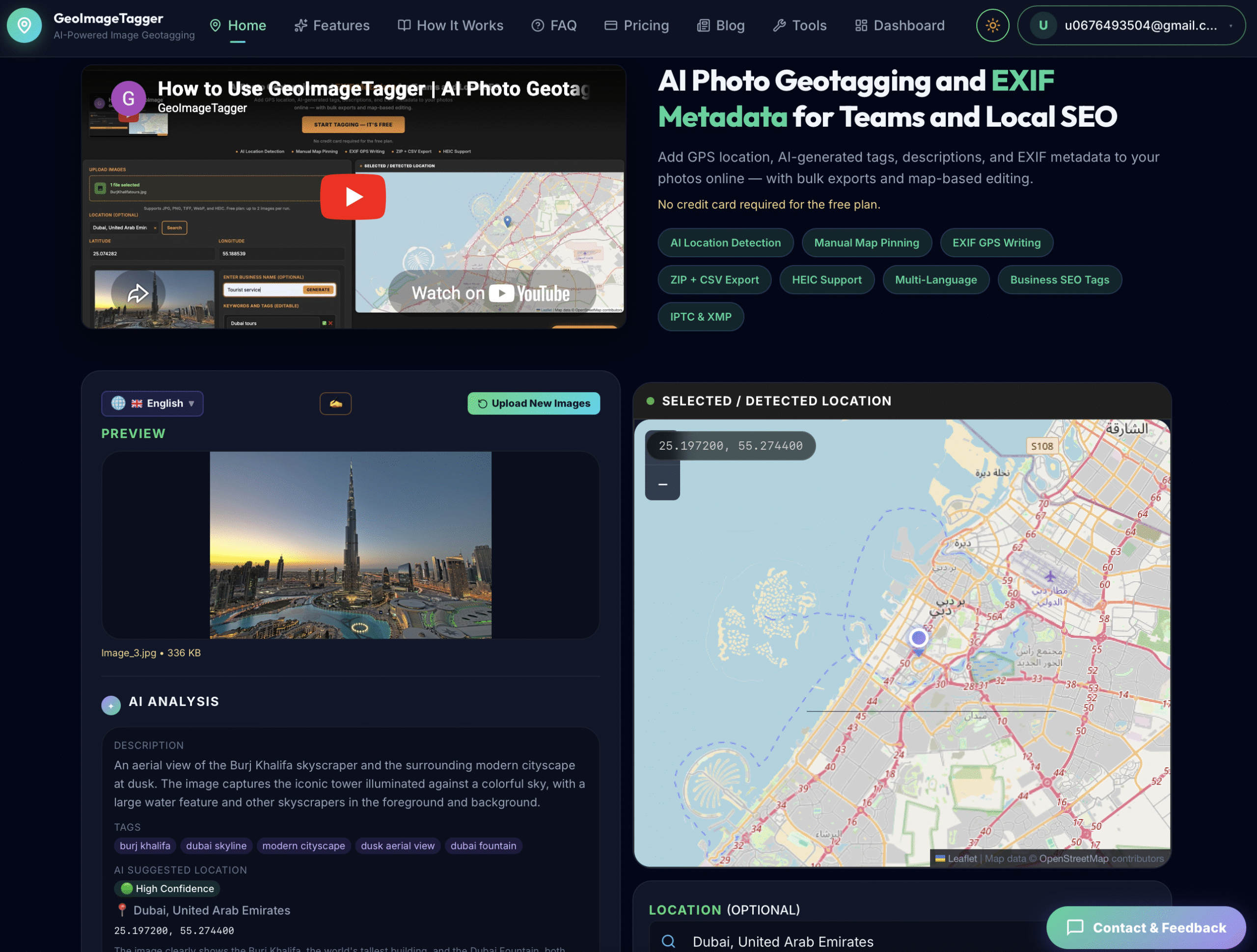
GeoImageTagger is a specialized platform designed to simplify photo geotagging and location-based image management. The tool helps users add, manage, and optimize geographic information within their photos, making it easier to organize images, improve local visibility, and maintain accurate location data. Whether you are a photographer, marketer, SEO professional, real estate agent, or business owner, GeoImageTagger provides an efficient way to handle image location data without requiring advanced technical knowledge. At its core, the platform functions as both an AI image location finder and a comprehensive geotagging solution, helping users work with image metadata in a faster and more accurate manner.
One of the most notable aspects of GeoImageTagger is its ability to combine traditional geotagging features with artificial intelligence. Instead of manually entering coordinates for every image, users can leverage its AI image location finder capabilities to identify and associate locations with photos more efficiently. This makes photo geotagging significantly easier for users who manage large image libraries or frequently work with location-based content. By streamlining the process of tagging and organizing images, the platform reduces manual effort while improving data accuracy.
The growing importance of location-based search has increased the demand for tools that support photo geotagging. Businesses that rely on local visibility often need a reliable way to associate images with geographic locations. GeoImageTagger addresses this need by offering features that support geo tagging photo online, allowing users to upload images, assign location information, and export updated files with embedded metadata. This process helps create more organized image collections while also supporting various digital marketing and local optimization workflows.
In addition to its geotagging functionality, GeoImageTagger serves as a practical image metadata editor. Metadata plays a crucial role in how images are categorized, stored, and interpreted by different systems. Through its editing tools, users can edit image metadata, update location information, and maintain consistency across image libraries. These capabilities are particularly valuable for professionals who manage large volumes of digital assets and require precise metadata management.
Another major use case for the platform is geotagging images for SEO. Local businesses, agencies, and marketers often seek ways to improve the relevance and organization of their visual content. GeoImageTagger enables users to add geographic information directly into image files, supporting local content strategies and helping businesses maintain well-structured image assets. While geotagging alone is not a guaranteed ranking factor, many organizations include geotagging images for SEO as part of their broader local optimization efforts.
The platform also appeals to users looking for a dedicated gps photo tagger. Rather than relying on complicated desktop applications, users can access a streamlined environment where location data can be added quickly and efficiently. Those searching for ways to add gps location to photo files can benefit from a straightforward workflow that minimizes complexity while maintaining accuracy. This makes GeoImageTagger suitable for both beginners and experienced professionals.
For users interested in social media and content marketing, GeoImageTagger can support workflows related to geo tagging on instagram and other platforms where location-based content plays a role. By maintaining accurate location information within images before publishing, users can create more organized media libraries and improve their content management processes. Combined with its AI image location finder functionality, the platform provides a practical solution for modern image organization.
The tool can also be viewed as a form of geo tagging software built specifically for image-based workflows. Unlike general-purpose metadata tools, GeoImageTagger focuses on location information, image organization, and geographic tagging. Users seeking geo tagging image online solutions can upload images, process them efficiently, and manage location details through a user-friendly interface. Whether the goal is professional asset management, local marketing, or simply organizing personal photographs, GeoImageTagger offers a focused approach to photo geotagging and geographic image management.
Key Highlights
- AI-Powered Location Detection: GeoImageTagger functions as an advanced AI image location finder, helping users identify and associate locations with images more efficiently than traditional manual methods. This capability reduces time spent entering coordinates while supporting accurate photo geotagging workflows
- Comprehensive Photo Geotagging Features: The platform is built specifically for photo geotagging, enabling users to add, update, and manage geographic information within image files. This makes it easier to organize image libraries and maintain consistent location data across projects
- Easy GPS Coordinate Integration: Users looking to add gps location to photo files can quickly embed location information into image metadata. This streamlined workflow eliminates many of the challenges traditionally associated with manual geotagging
- Online Geotagging Convenience: GeoImageTagger supports geo tagging photo online, allowing users to process images through a web-based environment rather than relying on complex desktop software installations
- Dedicated Geo Tagging Software: As a purpose-built geo tagging software solution, the platform focuses on geographic image management rather than offering a broad collection of unrelated editing tools. This specialization makes it particularly useful for location-based workflows
- Advanced Metadata Management: The platform serves as a capable image metadata editor, giving users greater control over image information. Those who need to edit image metadata can update and manage image details from a centralized interface
- Support for SEO Workflows: Many marketers utilize GeoImageTagger for geotagging images for seo, helping them maintain structured image assets and support local marketing initiatives. The platform provides tools that fit naturally into broader optimization strategies
- GPS Photo Tagging Functionality: As a reliable gps photo tagger, the platform enables users to associate photos with precise geographic coordinates. This feature is especially useful for photographers, real estate professionals, and businesses managing location-based imagery
- Efficient Image Organization: By combining metadata management with photo geotagging, GeoImageTagger helps users maintain organized collections of images that can be searched, categorized, and managed more effectively
- Geo Tagging Image Online Workflow: Users seeking a convenient geo tagging image online solution can process images directly through the platform, reducing technical barriers and improving workflow efficiency
- Useful for Social Media Content: Businesses and creators interested in geo tagging on instagram can leverage accurate location information as part of their broader content management process, ensuring images remain organized and location-aware
- Image Geo Management Capabilities: The platform supports various image geo workflows, helping users connect visual content with geographic information. This functionality is valuable for asset management, marketing, and documentation purposes
- Scalable for Different Industries: From photographers and marketers to agencies and local businesses, GeoImageTagger provides flexible tools that support a wide range of photo geotagging requirements
- User-Friendly Experience: Despite offering advanced functionality such as an AI image location finder, metadata management, and GPS tagging, the platform remains accessible to users with varying levels of technical expertise
- All-in-One Geotagging Solution: By combining photo geotagging, geo tagging software, image metadata editor capabilities, and AI-powered location detection, GeoImageTagger delivers a comprehensive solution for users who need efficient geographic image management